In early January 1494, the fleet of Columbus’s second voyage anchored at the site where he founded “Española’s” first permanent European settlement—named Isabela in honor of the queen. Most modern historians roundly criticize Columbus’s selection of the site, but my dramatization of his thinking in Encounters Unforeseen’s sequel (almost completed!) won’t be so negative. He had reconnoitered Española’s northern coast during his first voyage and spotted potential natural harbors available. Here are photos of alternatives he considered carefully on the second voyage and of Isabela.
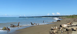
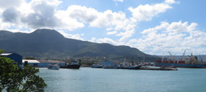
In November 1493, Columbus explored west of Chief Guacanagarí’s main township (at modern Bord de Mer de Limonade, Haiti), likely surveying the harbor at Cape Haitien (photo below taken from Point Picolet). He rejected the site because he believed its merits were insufficient to justify its distance from Española’s “gold mines,” which he believed lay farther east.
In early December 1493, Columbus’s fleet sheltered in the bay beside the high promontory he’d named Monte Christi, now Cabo del Morro, Dominican Republic, but he found the terrain too damp for settlement.
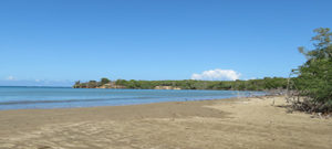
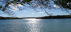
Columbus then sailed east toward two harbors he’d admired on the first voyage, the first a perfectly encircled inlet at modern Luperón, Dominican Republic, with a river he’d named Río de Gracia, and the second beneath a towering peak he’d named Monte Plata, at modern Puerto Plata. But the fleet fought storms and blistering headwinds for three weeks, and Columbus soon dispatched most of it back to languish at Monte Christi while he advanced in the nimblest caravels. He was disappointed on inspecting the inlet at Río de Gracia, likely concluding the river supplied insufficient water for his twelve hundred men and livestock. He could see Monte Plata’s pinnacle from the inlet’s outer bays (in first photo below), but a violent storm prevented his caravels from reaching the harbor at Monte Plata’s base (the second photo).
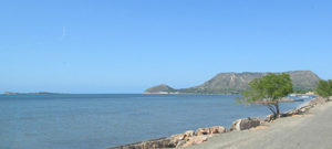
In late December, Columbus retreated to Monte Christi to reunite with his fleet and lead it to a site he’d reluctantly chosen, desperate to debark his men and livestock, exhausted from three months at sea. There was a cove protected from the easterly gales between Monte Christi and Río de Gracia, with a gushing river ample to support everyone (the Bajabonico), a stone quarry ideal for constructing permanent buildings, and a headland defensible from attack. Taínos weren’t resident on the headland, and, although Columbus didn’t know it, the area was borderland between the chiefdoms of Guacanagarí, Guarionex, and Mayobanex. The first photo shows the cove and site for Isabela from a distance. The second is taken from the likely mouth of the Bajabonico in 1494, the thatched roof being the preserved site of Columbus’s fortified residence.