The Guanahanían captives understood that Cuba was an island and told Columbus so. But, since early November, Columbus had believed Cuba was part of the Indies’ mainland.
On December 5, the Santa María and Niña passed Cuba’s eastern tip, modern Punta de Maisí, sailing east across the Windward Passage toward the Taíno Haiti (i.e., modern Haiti and the Dominican Republic). The Guanahaníans dreaded that cannibals who would eat them lived on Haiti. Columbus was disappointed when he sighted the Haitian coastline, as he realized that Haiti lay too close to the “Indies mainland” to be Marco Polo’s Japan.
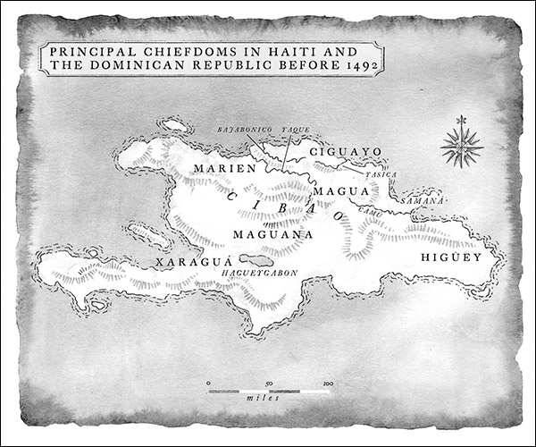
To recap, peace then reigned on the Taíno Haiti, with five caciques (chiefs)—including Caonabó, Guacanagarí, and Guarionex—ruling separate chiefdoms. Caonabó ruled his chiefdom of Maguana from a site at the modern San Juan de la Maguana, Dominican Republic. Guacanagarí ruled the chiefdom of Marien on Haiti’s northwestern coast—where Columbus’s ships soon would sail—likely from a site at the modern Haitian town of Bord de Mer de Limonade, a few miles east of Cape Haitien. Guarionex ruled his chiefdom of Magua in the present, fertile central valley of the Dominican Republic, likely from a site in the modern La Vega Vieja. Guacanagarí would soon meet and know Columbus, and Caonabó and Guarionex would know and have hostile encounters with Columbus on his second voyage. The map below, drawn for Encounters Unforeseen, shows the principal Haitian Taíno chiefdoms before 1492: