
At about N35⁰ W50⁰, Columbus reckoned that the North Star was as high in the sky as it appeared off Cape St. Vincent, Portugal (N 37⁰), indicating to him that he had sailed northeast from the Indies to approach the Azores (N 37-40⁰) from the southwest. What was his geographical conception of the voyage, and what was the Taíno captives’ reaction to the route since departing the Samaná peninsula (Dominican Republic)?
Aristotle had taught in the 4th century BC that the world was a globe, and Eratosthenes had fairly accurately estimated the earth’s equatorial circumference at 25,000 miles in 3rd century BC. The more renowned Ptolemy of the 2nd century AD had shortened that estimate to about 20,700 miles.
Europeans knew Terra Firma stretched west to east from Portugal to the Indies. But they generally assumed that, save for islands to be discovered, the Atlantic Ocean stretched west from Portugal all the way to the Indies. The Norse settlement that Eric the Red had established on Greenland in 985 AD was reflected on some European maps of the time. But, to the extent knowledge was disseminated of Greenland and the European settlements in northern North America established by Eric’s son Leif commencing in 1,001 AD, that dissemination didn’t alter the general absence of European understanding that great continents and civilizations lay between Europe and the Indies.
Most educated men in Portugal and Spain in 1492 believed the distance from Portugal to the Indies was too long to sail, the Ptolemaic-based estimation of the distance being greater than 8,000 miles. A minority believed the distance far shorter, one of them being a contemporary of Columbus named Martin Behaim, who constructed a globe in 1492 showing the following proximity of Portugal and the Indies, taken from John Fiske’s The Discovery of America. Boston & New York: Houghton, Mifflin and Co., 1902 (also included in Encounters Unforeseen):
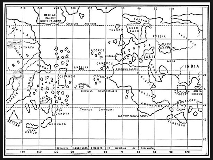
Columbus’s geographical conception was similar to Behaim’s, and Columbus independently claimed proof to Queen Isabella and King Ferdinand that the distance sailing from the Canary Islands to the “Cipangu” reflected on the Behaim map (i.e., the name Marco Polo used for Japan) was about 2,700 miles. Encounters Unforeseen portrays the evolution and maturation of Columbus “proof,” including his pre-1492 participation on voyages to Iceland and modern Ghana and his presentations to Portugal’s King John, Isabella and Ferdinand, and the commission they appointed to study his proposal.
The Taínos were skilled seafarers—Columbus himself was the first European to recognize this. They likely traded with Central and South American civilizations and had familiarity with the coastlines of those landmasses—hundreds of miles distant from their Caribbean homeland. But, as the ships coursed northeast, the Taíno captives must have been astounded how far the northern and eastern horizons extended, as well as how the temperature fell.